- (480) 983-3454
- info@azsalt.org
- Mon - Fri: 9:00AM - 5PM
Home > What We Do
The Superstition Area Land Trust (SALT) is dedicated to conserving the awe-inspiring vistas of the Superstitions, which is a product of both the threatened Superstition Foothills in the foreground AND the Superstition Mountains in the background within the SWA. The region is steeped in legend, history, and geological marvels. These mountains, officially designated as a Wilderness Area in 1964, are a tapestry of prehistoric ruins, volcanic flows, and the famous tales of the Lost Dutchman Gold Mine. The trails that wind through this rugged landscape are named after the prospectors and cowboys who once mined and ranched here, capturing some of the most beautiful and varied scenery on Earth.
The entire Superstitions area is a precious asset, offering easy access to the wild for city dwellers. But this accessibility is both a blessing and a curse, as urban encroachment threatens the very essence of the Wilderness. The 28,800 acres of State Land in the Foothills serve as a crucial buffer, providing habitat for rare and endangered species and hosting some of the region’s most popular trailheads.
SALT recognizes the urgent need to conserve these lands to ensure they remain a sanctuary for recreation and solitude. The region is perfect for a variety of outdoor activities, including hiking, backpacking, climbing, kayaking, canoeing, rafting, horse packing, bird watching, stargazing, and simply finding peace in nature. By protecting this gateway to the wilderness, SALT aims to protect the Superstitions for future generations to enjoy and explore.
Our Primary Mission is the long-term conservation and management for responsible recreation of the natural open space in ASLD land south of the Superstition Wilderness Area through collaboration, education, advocacy, land acquisitions, and other conservation actions.
SALT has strengthened its regional collaborative network to explore realistic possibilities for acquiring and maintaining lands, and the funds needed to do so. Potential sources include monies resulting from mining-related land exchanges, commercial entities interested in both acquisition and conservation, a conservation district, and various types of fees.
Regardless of how they are purchased, some entity will need to assume ownership and high-level management of these lands. Considerations range from some type of federal designation to county open space type park, or some various combinations. Whatever the designation, such an area would likely attract the tourism that would provide a major shot-in-the-arm for the regional economy and thus help justify designations.
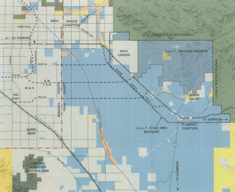
The Study Area for the Superstition Area Land Plan Includes 105 square miles. The Area is bordered on the north by the Superstition Wilderness Area, on the east by the Tonto National Forest, and by a line a mile southwest and south of U.S. 60.
A substantial area of undisturbed virgin Sonoran Desert open space lies on state trust lands, which if preserved, would serve as a buffer for the Superstition Wilderness and the Tonto National Forest. This would prove to be an economic and environmental asset for future development of the remaining adjacent state trust lands. The Superstition Area Land Trust (SALT) hired a planning consultant to develop a land use study. This study would serve as the recommended guide to helping SALT achieve its goals of protecting this area.
We would love your help, donations, or voice to help us protect and conserve the Superstition area. If interested please give us a call or contact us by clicking below!